西安樊川公园二期景观设计 | 中电建西北院+赤地设计
-
项目名称:西安市长安区全域治水樊川公园二期景观工程
-
项目地点:陕西省 西安市 长安区
-
项目规模:17.2公顷(258亩)
-
设计公司:
-
施工单位:中国水利水电第三工程局有限公司
-
委托方:西安市长安区水务局、长安城乡建设开发有限公司
-
建成时间:2021年
-
图片来源:张锦、宋昱
似乎没有什么能比一汪明镜的湖水更贴切地放置在这片场地之中,位于古城中轴线上的湖面,犹如“双面镜”倒映着秦岭山脉的巍峨壮丽,同时也折射着现代都市的异彩缤纷。
It seems that nothing can be more appropriately placed in this site than the lake water of a mirror. The lake surface located on the central axis of the ancient city is like a "double-sided mirror" reflecting the towering magnificence of the Qinling Mountains and the colorful modern city.
▼ 项目鸟瞰

项 目 概 述
2020年3月1日,西安市政府正式印发《全域治水碧水兴城西安市河湖水系保护治理三年行动方案》,全面启动全域治水建设生态西安的目标。其中潏河及其支流共涉及21个河道治理项目,是全域治水的重点。潏河发源于秦岭北麓,古时是渭河的一级支流,也是西安最富盛名的河流。唐代后改道入交河汇入沣河,今属沣河的主要支流,系渭河的二级支流。古称泬水,今亦称决河。
场地位于潏河流入长安城区段,占地约258亩。河水流经樊川,蜿蜒流淌于神禾原坡之下,常年淤积变道在此形成宽阔河滩。人为扰动加之历年洪泛肆虐,滩地荒芜贫瘠,成为潏河留在土地上的一处“伤疤”。随着城市发展需求和全域治水工程推进,场地治理提升迫在眉睫。
On March 1, 2020, Xi'an municipal government officially issued the three-year action plan for the protection and treatment of Xi'an River and lake water systems, which comprehensively launched the goal of water control and ecological Xi'an. Among them, Yuhe River and its tributaries involve 21 river channel treatment projects, which is the focus of water control in the whole region. Originating from the north foot of Qinling Mountains, Yuhe River was the first-class tributary of Weihe River in ancient times and the most famous river in Xi'an. After the Tang Dynasty, it was diverted into Jiaohe River and merged into Fenghe river. Now it is the main tributary of Fenghe River and the secondary tributary of Weihe River. In ancient times, it was called Jishui, and now it is also called Jue river.
The site is located in the section where the Yuhe river flows into Chang'an urban area, covering an area of about 258 mu. The river flows through Fanchuan and meanders under the Shenheyuan slope. It is silted and diverted all year then form a wide beach here. Human disturbance and flooding over the years have made the beach barren and barren, which has become a "Scar" left on the land by Yuhe River. It is urgent to promote the development of urban site and water control projects.
▼ 场地区位

三 个 挑 战
Three challenges
1.场地空间平淡无奇,如何通过设计使场地生动有趣,并赋予公园更丰富的人文内涵是设计面临的第一项挑战。
2.场地北侧被潏河与河堤路割裂,南侧则被高差近20米的神禾原坡阻挡,如何将场地与环境有效融合是本项目面临的第二项挑战。
3.场地内90%的用地为荒滩地,旱涝叠替,不适宜植被生长,生态系统修复是设计面临的第三项挑战。
1. The space of the site is ordinary. How to make the site lively and interesting and endow the park with richer humanistic connotation through design?This is the first challenge faced by the design.
2. The north side of the site is separated by Yuhe River and Hedi Road, and the south side is blocked by shenheyuan slope with an elevation difference of nearly 20m. How to effectively integrate the site with the environment is the second challenge facing the project.
3. 90% of the land in the site is wasteland, with repeated drought and flood, which is not suitable for vegetation growth. Ecosystem restoration is the third challenge facing the design.
▼ 设计前(2020年6月)

▼ 设计后(2021年6月)

设 计 策 略
1.通过对空间和水文要素的系统梳理,设计将一个面积约54亩的调蓄水面嵌入河滩地中,湖水将四周的景色纳入其中,不同视点给人们呈现出丰富多变的景观场景。同时,作为古城中轴线上重要的“节点”,其成为联系城市和秦岭之间的一个支点,通过更稳固的方式将公园融入巨大的时空视野之中。
2.场地内土方达到就地平衡,利用挖土堆填塑造起丰富的景观地形系统,构建了两条不同防洪等级的河堤,并打造了一处绝佳的露营坡地。20年一遇的生态护堤像一条富有韧性的纽带,使湖面与河道保持一定的弹性空间;50年一遇的护堤则在消化多余土方的同时起到保护原坡稳定的安全作用。 3.架空栈道系统为人们感受美景提供了丰富途径。栈桥穿梭在高大的杨树之间,横跨在潏河之上,通过缓坡与园路连为一体;滨水栈道作为陆地向水面伸展的一部分,使人们得以更接近水体;架空挑台则利用场地高差形成远眺的观景点。
1. Through the systematic combing of spatial and hydrological elements, a regulation and storage water surface with an area of about 54 Mu is designed to be embedded into the river beach. The lake water includes the surrounding scenery, and different viewpoints present people with rich and changeable landscape scenes. At the same time, as an important "node" on the central axis of the ancient city, it has become a fulcrum connecting the city and Qinling Mountains, integrating the park into the huge space-time vision in a more stable way.
2.The earthwork in the site is balanced locally, the excavation and filling are used to shape a rich landscape and terrain system, two river embankments with different flood control levels are constructed, and an excellent camping slope is created. The once-in-20-year ecological berm is like a tenacious link, keeping a certain elastic space between the lake and the river; The 50 year return berm plays a safe role in protecting the stability of the original slope while digesting the excess earthwork.
3.The overhead trestle system provides a rich way for people to feel the beauty. The trestle shuttles between tall poplars, crosses the Yuhe River. And it is connected with the garden road through a gentle slope; As a part of the land extending to the water surface, the waterfront plank road makes people closer to the water body; The overhead platform uses the height difference of the site to form a scenic spot of the distant view.
▼ 通过就地土方平衡策略解决场地综合问题

▼ 架空栈道系统为人们体验美景提供丰富途径

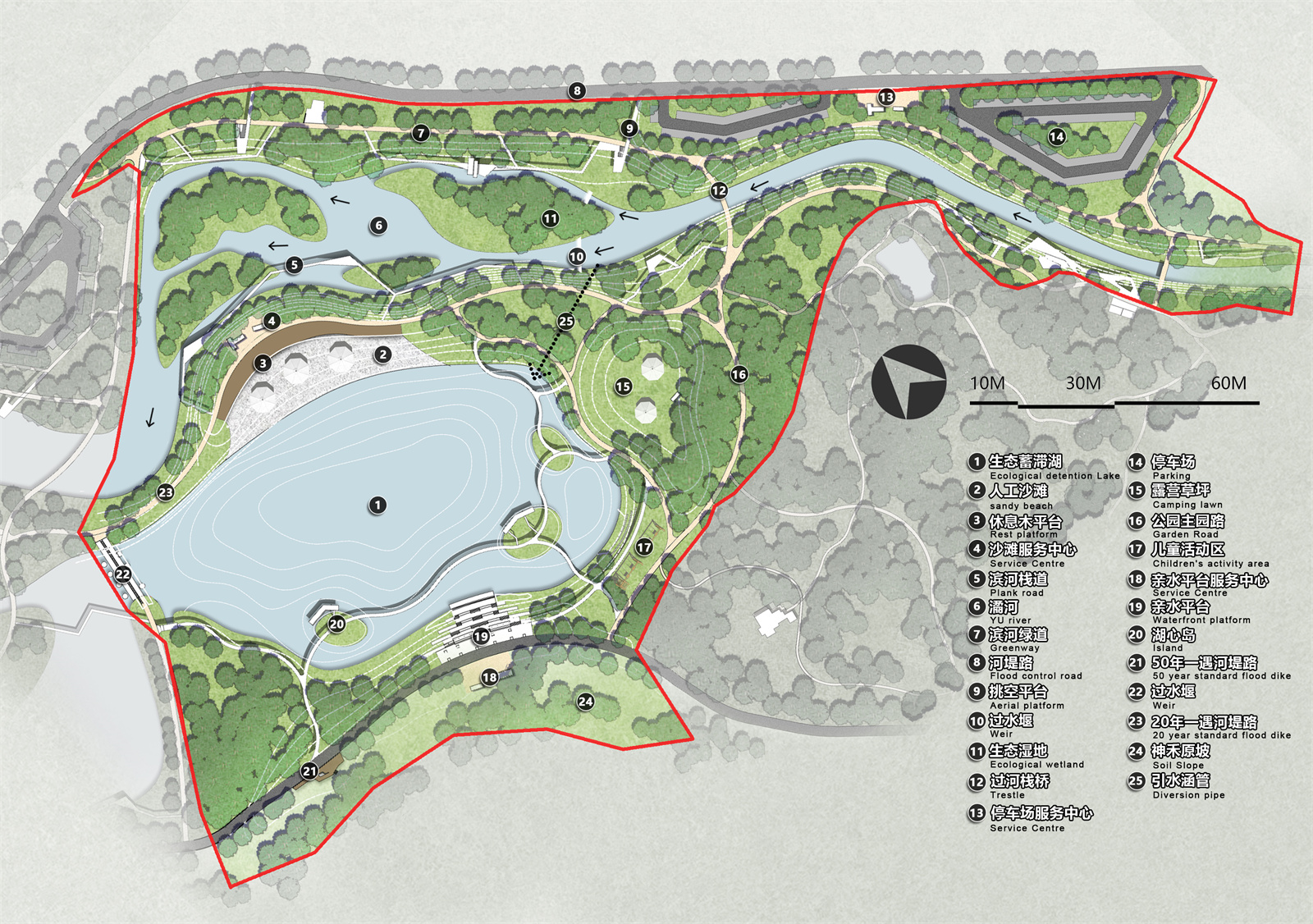
▼ 规划总平面图

建 成 效 果 一
( 夜景 / 2021年6月 )
一面是城市,一面是自然,公园以某种媒介的方式镶嵌在场地之中,将割裂的城市边缘与自然融为一体,使原本荒滩野地焕发生机。华灯初上,公园里的游客络绎不绝,人们享受着城市生活与自然体验的便捷转换。
One side is the city and the other is the nature. The park is embedded in the site in a certain medium, integrating the separated urban edge with the nature, so as to make the original wasteland full of vitality. At the beginning of the Lantern Festival, there are an endless stream of tourists in the park. People enjoy the convenient transformation between urban life and natural experience.
▼ 一面是城市

▼ 一面是自然

▼ 夜景鸟瞰


▼ 临水休憩的市民


建 成 效 果 二
( 日景 / 2021年6月 )
湖面与场地中保留的高大杨树交织成一道蓝绿画面,各功能区环绕在湖区四周,园路交织成网串联起各个区域,人们围绕着水展开了丰富的休闲活动。
The lake and the tall poplars retained in the site are intertwined into a blue-green picture. Each functional area is surrounded by the lake area, and the garden roads are intertwined into a network to connect each area. People have carried out rich leisure activities around the water.
▼ 滨湖栈道


▼ 亲水平台与廊架

▼ 拱形爬藤长廊


▼ 根据保留下来的杨树而设计的儿童活动场地

▼ 儿童活动区


▼ 沙滩区


▼ 露营区


▼ 跨河栈桥

▼ 观景眺台

▼ 过水堰

建 成 效 果 三
( 冬景 / 2020年12月 )
冬日的公园透彻艳丽,白色的栈道勾勒出飘逸的曲线,红黄交错的张拉膜点缀其中,成为场地中的视线焦点。抛石驳岸满足了水边界的安全,并最大限度保持生态性;过水堰则巧妙运用古人灌溉理水经验,将河道分级并引水入湖。
In winter, the park is clear and gorgeous, the white walkway outlines the elegant curve, and the red and yellow interlaced tension membrane embellishes it, which has become the focus of attention in the site. The ripped-rock revetment meets the safety of water boundary and maintains ecology to the greatest extent; The overflow weir skillfully uses the ancient irrigation and water management experience to classify the river channel and divert water into the lake.
▼ 城市与公园


▼ 湖心岛与栈道

▼ 滨水休息平台

▼ 儿童活动区

▼ 现状柳树与过水堰

▼ 栈道与挑台

▼ 生态抛石驳岸

▼ 过水堰


▼ 整体鸟瞰


小 结
设计初衷是对局部场地的考量放入到更宏观的空间语境中,宽阔的湖面从尺度上回应了城市边界高耸的楼宇和远处山脉的自然景象。这种方式强化了人们对景观体验的另外一种感知——即在置身某处的同时唤醒人与自然的一种原始沟通。公园建成后市民很快适应并喜欢上这一处新环境,其一度成为西安热度最高的公共空间。
从现场踏勘到公园基本建成仅仅用了6个月时间,这对整个项目团队无疑是巨大考验,设计团队通过相互紧密配合,深度而高效的现场服务,顺利完成了这项艰巨的任务。
The original intention of the design is to put the consideration of local sites into a broader spatial context. The wide lake responds to the natural scenes of towering buildings on the urban boundary and distant mountains on a large scale. This way strengthens people's perception of landscape experience, that is, to awaken a primitive communication between man and nature while being somewhere. After the completion of the park, citizens quickly adapt to and like this new environment, which once became the hottest public space in Xi'an.
It took only six months from the site survey to the basic completion of the park, which is undoubtedly a great test for the whole project team. The design team successfully completed this arduous task through close cooperation and in-depth and efficient on-site service.
项目信息
项目名称:西安市长安区全域治水樊川公园二期景观工程
项目地点:陕西省 西安市 长安区
业主单位:西安市长安区水务局
长安城乡建设开发有限公司
设计单位:中国电建集团西北勘测设计研究院有限公司
上海赤地设计事务所
建设单位:中国水利水电第三工程局有限公司
项目规模:17.2公顷(258亩)
设计时间:2020年5月
竣工时间:2021年1月
摄影团队:张锦 宋昱
图片版权:赤地设计
Project Name: phase II landscape project of Global water control Fanchuan Park, Chang'an District, Xi'an City
Project location:Chang'an District, Xi'an City,Shanxi Province
Owner: Water Affairs Bureau,Chang'an District,Xi'an City.
Chang'an urban and rural construction and Development Co.,Ltd.
Designer: Northwest Survey, design and Research Institute Co.,Ltd. of China Power Construction Group
Shanghai CHIDI Design Office
Employer: Sinohydro bureau 3 Co., Ltd
Project scale: 17.2 ha (258 mu)
Design time: May, 2020
Completion time: January 2021
Photography team: Zhang Jin ,Song Yu
Copyright: Design in CHIDI
版权声明:本文版权归原作者所有,请勿以景观中国编辑版本转载。如有侵犯您的权益请及时联系,我们将第一时间删除。
投稿邮箱:info@landscape.cn
项目咨询:18510568018(微信同号)